 |
SoundPLAN-essential is a compact version of SoundPLAN. SoundPLAN-essential is a single document application including all the basic information for noise control modeling and planning. It calculates noise from roads, railways or industrial noise sources. The computation can include one or multiple noise sources. The software provides a system noise emission library for defining 1/3 octave and 1/1 band spectral information. The user can create a project noise emission library and a customized over time a global library. The user can customize which noise source combination are computed and presented. The calculations are completed for a single or multiple noise type at the same time. User selects which calculation guidelines and assessment methods are selected for the project. SoundPLAN essential v5.1 now provides a direct interface to Google Map (c) and allows the import of geo-referenced aerial photos and topographical information (i.e., spot elevation) and Open Street Map (OSM) information such as roads, buildings, .... Navcon Engineering Network is the North American Distributor of SoundPLAN essential and provide technical hotline, software training and sales support. SoundPLANessential v5.1 Trial Software and Brochure Demo / Trial Software Download (160 MB) (To install the software as a full trial version please contact Navcon for a trial license - forschner (at) navcon.com ) Essential Brochure (3.5 MB) SoundPLANessential brochure Standards The SoundPLAN essential v5.1 software incorporates 25+ noise modeling standards. For the North American market SoundPLAN essential v5.0 provides a set of model solutions / standards for outdoor noise modeling that include: |
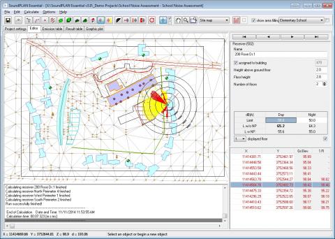 |
SoundPLAN-essential calculates any amount of data, so it can process any job. Data is imported from GIS and CAD, or digitized on top of bitmaps. It includes all the basic tools and editing functions. The results from receptor computation and contour calculation are documented in result tables and colored graphics. The emission level calculations and results of the noise propagation are presented in tabular form in predefined tables. Grid noise maps are used for color contour maps for day and night or the Lden time slots, depending on the standard. The grid noise maps and noise contour maps show the dB values using color bands or the dB value itself. SoundPLAN-essential predicts the noise levels for single receivers and develops noise contour maps based upon grid noise calculations. A “single receiver” calculation shows the noise levels, assesses the correct time slots and applies the level additions for the noise descriptor required in the country for all receivers and floors. The level chart shows the magnitude of the noise received. |
 |
SoundPLAN-essential predicts the noise levels for single receivers and develops noise contour maps based upon grid noise calculations. A “single receiver” calculation shows the noise levels, assesses the correct time slots and applies the level additions for the noise descriptor required in the country for all receivers and floors. The level chart shows the magnitude of the noise received.
|
 |
SoundPLAN Essential provides Noise Models for:
SoundPLAN Essential Modeling Objects include:
Features Include:
Result Tables and Graphics: The emission level calculations and the results of the noise propagation are presented in tabular form in predefined tables. Additional text can be added for map descriptions and you can customize the layout for each object.
SoundPLAN essential Demo Version: Please download the file to your hard disk (i.e., c:\temp). To install the software unzip the file (InstallSPES3.0.zip) and start the installation by click on the "InstallSPES3.0.exe". SoundPLAN Essential V2 Download (~ 72 Mb) Note: The demo version will install 3 example projects on your system. You will be able to review the projects and play with the data and results. The demo version does not save any changes. |